Norris School District
School Site Information
School Accountability Report Cards for each of our school sites, available in English and Spanish, along with district boundary information for families.
Our schools
School Accountability Report Cards
Choose a school below to open its 2024–25 School Accountability Report Card (SARC). Each report is available in English and Spanish as a PDF that opens in a new tab.
Norris Elementary School
Transitional Kindergarten – 6th grade
2024–25 School Accountability Report Card
Olive Drive Elementary School
Transitional Kindergarten – 6th grade
2024–25 School Accountability Report Card
Veterans Elementary School
Transitional Kindergarten – 6th grade
2024–25 School Accountability Report Card
William B. Bimat Elementary School
Transitional Kindergarten – 6th grade
2024–25 School Accountability Report Card
Norris Middle School
7th – 8th grade
2024–25 School Accountability Report Card
About the School Accountability Report Card
California public schools publish an annual School Accountability Report Card (SARC). Each report shares information about the school's students and staff, curriculum and instructional materials, facilities, class sizes, test results, and school safety, so families and community members can see how their school is doing.
A printed copy of any report card is available at no charge on request from the school office or the Norris School District office.
Attendance areas
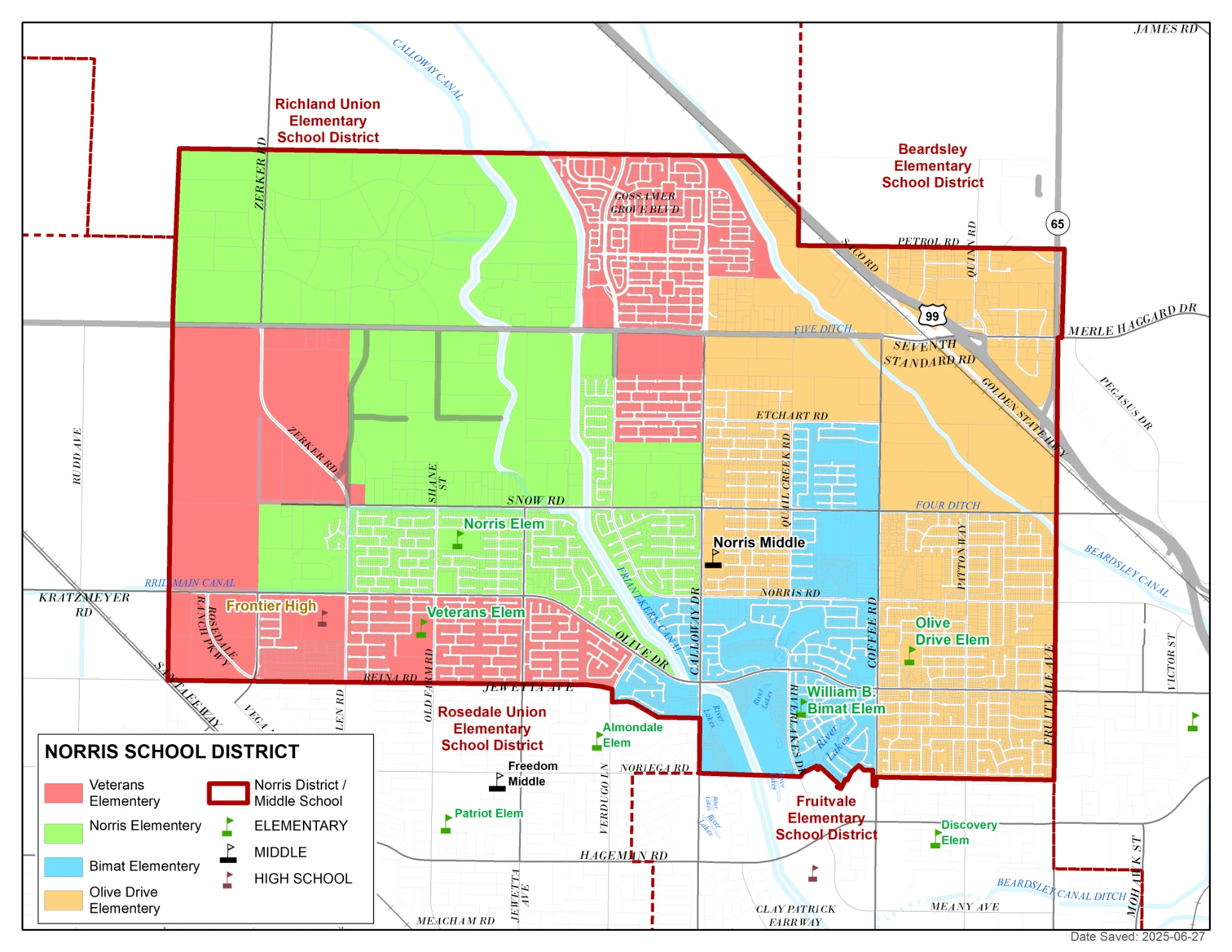
District Boundary Map
This map shows the Norris School District boundary and the elementary attendance area for each school. All students in the district attend Norris Middle School for 7th and 8th grade. If you need help determining which school serves your address, please contact the Norris School District office.
Attendance Areas in Words
A written summary of the map, for anyone who cannot view the image:
- Veterans Elementary — the southwest portion of the district, generally west of Old Farm Road and south of Snow Road, including the Rosedale Ranch Parkway, Reina Road, and Jewetta Avenue neighborhoods, plus the area north along Zerker Road.
- Norris Elementary — the central and northwest portion of the district, generally between Zerker Road and the Calloway Canal area, including the neighborhoods along Shane Street and Snow Road.
- William B. Bimat Elementary — the south-central portion of the district around Calloway Drive, Riverlakes Drive, and the River Lakes area, east to Coffee Road.
- Olive Drive Elementary — the eastern portion of the district, generally east of Coffee Road and Quail Creek Road out to Fruitvale Avenue, including the Patton Way and Norris Road neighborhoods.
- Norris Middle School — serves all 7th and 8th grade students district-wide.
Neighboring districts shown on the map for reference include Richland Union, Beardsley, Rosedale Union, and Fruitvale Elementary School Districts.